Sale on canvas prints! Use code ABCXYZ at checkout for a special discount!

Boundary: Bleed area may not be visible.


by Paul Fearn
$47.00
This product is currently out of stock.
Size
Orientation
Image Size
Product Details
You'll never run out of power again! If the battery on your smartphone or tablet is running low... no problem. Just plug your device into the USB port on the top of this portable battery charger, and then continue to use your device while it gets recharged.
With a recharge capacity of 5200 mAh, this charger will give you 1.5 full recharges of your smartphone or recharge your tablet to 50% capacity.
When the battery charger runs out of power, just plug it into the wall using the supplied cable (included), and it will recharge itself for your next use.
Design Details
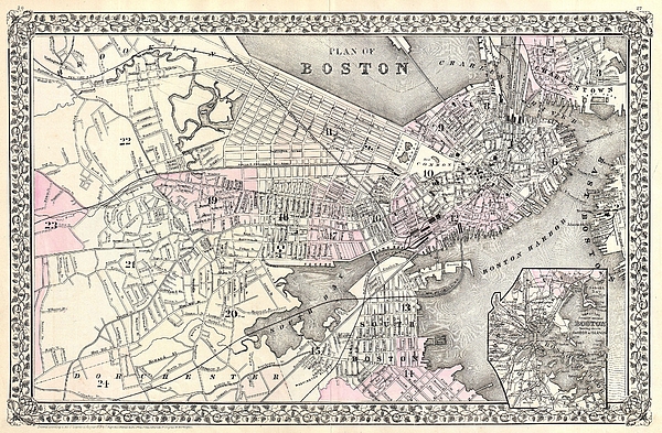
A beautiful example of S. A. Mitchell Jr.�s 1879 map of Boston, Massachusetts. Covers Boston as far east as Brookline and as far south as Dorchester.... more
Dimensions
1.80" W x 3.875" H x 0.90" D
Ships Within
1 - 2 business days
A beautiful example of S. A. Mitchell Jr.�s 1879 map of Boston, Massachusetts. Covers Boston as far east as Brookline and as far south as Dorchester. Detailed to the level of individual buildings and streets. An inset in the lower right quadrant depicts Boston Harbor. Features the vine motif border typical of Mitchell maps from the 1866 - 1882 period. Prepared by S. A. Mitchell for inclusion as plate nos. 26 and 27 in the 1880 issue of Mitchell�s New General Atlas . Dated and copyrighted, �Entered according to Act of Congress in the Year 1879 by S. A. Mitchell in the Office of the Librarian of Congress at Washington.
My passion is Photography and Aviation or is that Aviation and Photography ! I hope you enjoy my photographs.
$47.00


There are no comments for 1879 Mitchell Map of Boston Massachusetts. Click here to post the first comment.