Sale on canvas prints! Use code ABCXYZ at checkout for a special discount!

Boundary: Bleed area may not be visible.

Inside Message (Optional)
Inside View

by Paul Fearn
$6.45
Quantity
The more you buy... the more you save.
Orientation
Image Size
Product Details
Our greeting cards are 5" x 7" in size and are produced on digital offset printers using 100 lb. paper stock. Each card is coated with a UV protectant on the outside surface which produces a semi-gloss finish. The inside of each card has a matte white finish and can be customized with your own message up to 500 characters in length. Each card comes with a white envelope for mailing or gift giving.
Design Details
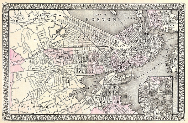
A beautiful example of S. A. Mitchell Jr.�s 1879 map of Boston, Massachusetts. Covers Boston as far east as Brookline and as far south as Dorchester.... more
Ships Within
2 - 3 business days
A beautiful example of S. A. Mitchell Jr.�s 1879 map of Boston, Massachusetts. Covers Boston as far east as Brookline and as far south as Dorchester. Detailed to the level of individual buildings and streets. An inset in the lower right quadrant depicts Boston Harbor. Features the vine motif border typical of Mitchell maps from the 1866 - 1882 period. Prepared by S. A. Mitchell for inclusion as plate nos. 26 and 27 in the 1880 issue of Mitchell�s New General Atlas . Dated and copyrighted, �Entered according to Act of Congress in the Year 1879 by S. A. Mitchell in the Office of the Librarian of Congress at Washington.
My passion is Photography and Aviation or is that Aviation and Photography ! I hope you enjoy my photographs.
$6.45


There are no comments for 1879 Mitchell Map of Boston Massachusetts. Click here to post the first comment.