Sale on canvas prints! Use code ABCXYZ at checkout for a special discount!

Boundary: Bleed area may not be visible.


by Paul Fearn
$70.00
This product is currently out of stock.
Image Size
Product Details
Here it is... the towel that's taking the internet by storm. Our round beach towels are 60" in diameter and made from ultra-soft plush microfiber with a 100% cotton back. Perfect for a day at the beach, a picnic, an outdoor music festival, or just general home decor. This versatile summer essential is a must-have this season!
Design Details
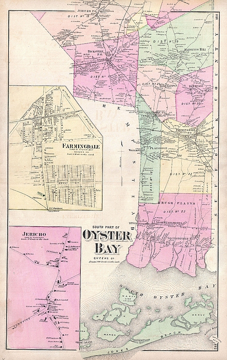
A scarce example of Fredrick W. Beers� map of the southern part of Oyster Bay Queens, New York. Published in 1873. Covers roughly from Jones Beach... more
Dimensions
60" Diameter Not Including Tassles
Care Instructions
Machine wash cold and tumble dry with low heat.
Ships Within
2 - 3 business days
A scarce example of Fredrick W. Beers� map of the southern part of Oyster Bay Queens, New York. Published in 1873. Covers roughly from Jones Beach northward as far as Jericho. Includes inset plans of Farmingdale and Jericho. Detailed to the level of individual buildings and properties with land holders noted. This is probably the finest atlas map of northern Oyster Bay, Long Island, to appear in the 19th century. Prepared by Beers, Comstock & Cline out of their office at 36 Vesey Street, New York City, for inclusion in the first published atlas of Long Island, the 1873 issue of Atlas of Long Island, New York.
My passion is Photography and Aviation or is that Aviation and Photography ! I hope you enjoy my photographs.
$70.00


There are no comments for 1873 Beers Map of Oyster Bay Queens New York City . Click here to post the first comment.