Sale on canvas prints! Use code ABCXYZ at checkout for a special discount!

Boundary: Bleed area may not be visible.

Inside Message (Optional)
Inside View

by Paul Fearn
$6.45
Quantity
The more you buy... the more you save.
Orientation
Image Size
Product Details
Our greeting cards are 5" x 7" in size and are produced on digital offset printers using 100 lb. paper stock. Each card is coated with a UV protectant on the outside surface which produces a semi-gloss finish. The inside of each card has a matte white finish and can be customized with your own message up to 500 characters in length. Each card comes with a white envelope for mailing or gift giving.
Design Details
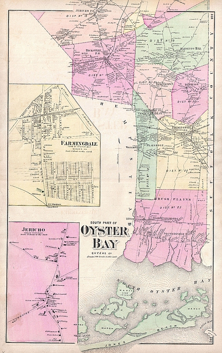
A scarce example of Fredrick W. Beers� map of the southern part of Oyster Bay Queens, New York. Published in 1873. Covers roughly from Jones Beach... more
Ships Within
2 - 3 business days
A scarce example of Fredrick W. Beers� map of the southern part of Oyster Bay Queens, New York. Published in 1873. Covers roughly from Jones Beach northward as far as Jericho. Includes inset plans of Farmingdale and Jericho. Detailed to the level of individual buildings and properties with land holders noted. This is probably the finest atlas map of northern Oyster Bay, Long Island, to appear in the 19th century. Prepared by Beers, Comstock & Cline out of their office at 36 Vesey Street, New York City, for inclusion in the first published atlas of Long Island, the 1873 issue of Atlas of Long Island, New York.
My passion is Photography and Aviation or is that Aviation and Photography ! I hope you enjoy my photographs.
$6.45


There are no comments for 1873 Beers Map of Oyster Bay Queens New York City . Click here to post the first comment.