Sale on canvas prints! Use code ABCXYZ at checkout for a special discount!

Boundary: Bleed area may not be visible.

The watermark at the lower right corner of the image will not appear on the final product.

by Paul Fearn
$35.00
Size
Orientation
Image Size
Product Details
Decorate your bathroom and dry yourself off with our luxuriously soft bath towels and hand towels. Our towels are made from brushed microfiber with a 100% cotton back for extra absorption. The top of the towel has the image printed on it, and the back is white cotton. Available in three different sizes: hand towel, bath towel, and bath sheet.
Design Details
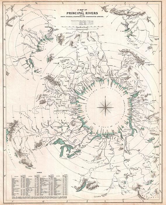
This curious comparative rivers chart published in 1834 by the Society for the Diffusion of Useful Knowledge is somewhat unique in that it imagines... more
Care Instructions
Machine wash cold and tumble dry with low heat.
Ships Within
1 - 2 business days
This curious comparative rivers chart published in 1834 by the Society for the Diffusion of Useful Knowledge is somewhat unique in that it imagines all of the great rivers of the world letting out into a circular inland sea. Concentric circles show the general lengths of the rivers as the bird files, but cannot take into account the twists and turns of the rivers themselves. What this chart does show is, to a degree, the direction and course of the rivers' flow. Direction, which in other comparative rivers charts is indicated textually, here is illustrated visually. Nevertheless, though innovative and physically attractive, this S.D.U.K. comparative rivers chart never caught on beyond its initial publication. Drawn by Baldwin and Craddock of 47 Paternoster Row, London, for the Society for the Diffusion of Useful Knowledge Atlas , volume 1. Dated and copyrighted April 1, 1834.
My passion is Photography and Aviation or is that Aviation and Photography ! I hope you enjoy my photographs.
$35.00


Socozora S
Congratulations on your sale
Cathy Lindsey
Nice! Congratulations on your sale!