Sale on canvas prints! Use code ABCXYZ at checkout for a special discount!

Boundary: Bleed area may not be visible.


by Paul Fearn
$35.00
Size
Orientation
Image Size
Product Details
Decorate your bathroom and dry yourself off with our luxuriously soft bath towels and hand towels. Our towels are made from brushed microfiber with a 100% cotton back for extra absorption. The top of the towel has the image printed on it, and the back is white cotton. Available in three different sizes: hand towel, bath towel, and bath sheet.
Design Details
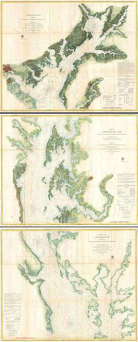
This is a monumental and rarely available three part 1857 nautical chart or maritime map of the Chesapeake Bay. Prepared for the 1857 edition of the... more
Care Instructions
Machine wash cold and tumble dry with low heat.
Ships Within
1 - 2 business days
This is a monumental and rarely available three part 1857 nautical chart or maritime map of the Chesapeake Bay. Prepared for the 1857 edition of the U.S. Coast Survey’s Superintendent’s Report this giant map covers from the top of the Chesapeake Bay and the mouth of the Susquehanna River to the mouth of the Potomac River. The top or first chart covers from the head of the Bay to the Mouth of the Magothy River, inclusive of the Patapsco River and the city of Baltimore – which is detailed to the street level. The second or middle chart covers from the Magothy River to the mouth of the Hudson River and includes Annapolis, Cambridge, and Easton. This second chart also bears the title of the three map series in addition to its individual title. The bottom or third chart in this series covers from the mouth of the Hudson River to the mouth of the Potomac River. The United States Coast Survey considered the construction of a detailed map of the Chesapeake Bay to be one of its top priori...
My passion is Photography and Aviation or is that Aviation and Photography ! I hope you enjoy my photographs.
$35.00


Andrea Hazel
Congratulations
Naedja Maciel
Congratulation on your sale Dean.
Fantastic Designs
Congrats on your sale!
Dean Wittle
Congratulations on your sale today!!!