Sale on canvas prints! Use code ABCXYZ at checkout for a special discount!

Boundary: Bleed area may not be visible.


by Paul Fearn
$47.00
This product is currently out of stock.
Size
Orientation
Image Size
Product Details
You'll never run out of power again! If the battery on your smartphone or tablet is running low... no problem. Just plug your device into the USB port on the top of this portable battery charger, and then continue to use your device while it gets recharged.
With a recharge capacity of 5200 mAh, this charger will give you 1.5 full recharges of your smartphone or recharge your tablet to 50% capacity.
When the battery charger runs out of power, just plug it into the wall using the supplied cable (included), and it will recharge itself for your next use.
Design Details
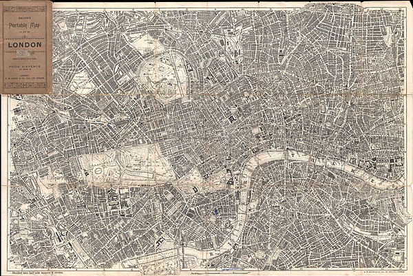
Extremely attractive map of London, England aroun the turn of the century. Issued c. 1899 by G. W. Bacon, this map covers central London along the... more
Dimensions
1.80" W x 3.875" H x 0.90" D
Ships Within
1 - 2 business days
Extremely attractive map of London, England aroun the turn of the century. Issued c. 1899 by G. W. Bacon, this map covers central London along the Thames River from Fulham Cemetary in the west to Southwark Park in the southeast. Extends north as far as Canonbury and Kentish Town. Includes Regents Park, Kensington Garden, Hyde Park, St. James Places, the London Docks, the Great North Railway Dept and London Fields, among other destinations. Labels all streets, ferry routes, bridges, train routes, parks, and countless important buildings and civic constructions. Folds into original wax paper binder.
My passion is Photography and Aviation or is that Aviation and Photography ! I hope you enjoy my photographs.
$47.00


There are no comments for 1899 Bacon Pocket Plan or Map of London . Click here to post the first comment.