Sale on canvas prints! Use code ABCXYZ at checkout for a special discount!

Boundary: Bleed area may not be visible.


by Paul Fearn
$35.00
Size
Orientation
Image Size
Product Details
Our luxuriously soft beach towels are made from brushed microfiber with a 100% cotton back for extra absorption. The top of the towel has the image printed on it, and the back is white cotton. Our beach towels are available in two different sizes: beach towel (32" x 64") and beach sheet (37" x 74").
Don't let the fancy name confuse you... a beach sheet is just a large beach towel.
Design Details
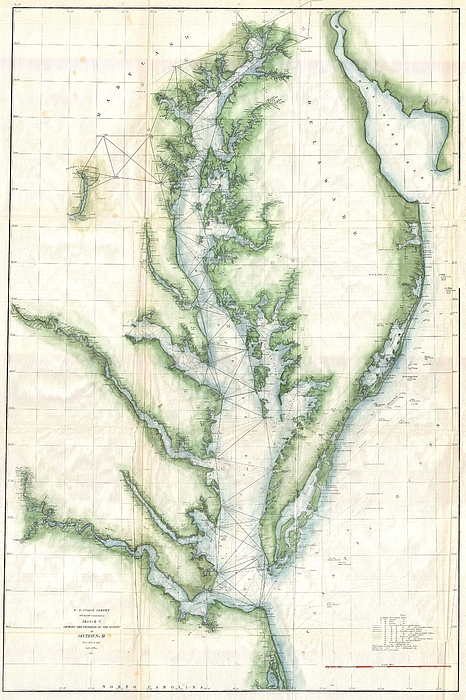
1859 U.S. Coast Survey's progress chart of the Chesapeake Bay. The map covers from the mouth of the Susquehanna River southwards as far as Cape... more
Care Instructions
Machine wash cold and tumble dry with low heat.
Ships Within
1 - 2 business days
1859 U.S. Coast Survey's progress chart of the Chesapeake Bay. The map covers from the mouth of the Susquehanna River southwards as far as Cape Henry and Norfolk. This chart includes both the Chesapeake Bay and Delaware Bay in full, as well as small portions of the Potomac River, Rappahannock River, York River, James River, Patapsco River and Patuxent River. Washington D.C., Cape May, Charleston, Baltimore, Annapolis, Chestertown, Easton, Cambridge and Norfolk, are identified. Triangulation points are noted throughout the region as well as all major islands, rivers, and inlets. Prepared under the supervision of A. D. Bache 1857 Superintendent's Report .
My passion is Photography and Aviation or is that Aviation and Photography ! I hope you enjoy my photographs.
$35.00


Alain De Maximy
Congratulation on your sale!
Sunil Kapadia
Congratulations!
Dean Wittle
Congratulations on your sale today!!!
Gull G
Congratulations on your sale!