Sale on canvas prints! Use code ABCXYZ at checkout for a special discount!

Boundary: Bleed area may not be visible.

The watermark at the lower right corner of the image will not appear on the final product.

by Paul Fearn
$27.00
Model
Case Style
Orientation
Image Size
Product Details
1799 Cruttwell Map of the United States of America iPhone case by Paul Fearn. Protect your iPhone with an impact-resistant, slim-profile, hard-shell case. The image is printed directly onto the case and wrapped around the edges for a beautiful presentation. Simply snap the case onto your iPhone for instant protection and direct access to all of the phone's features!
Design Details
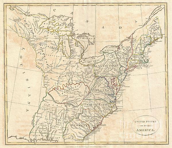
This is a highly unusual and extremely scarce 1799 map of the United States by the English map publisher Clement Cruttwell. Depicts a post-colonial... more
Ships Within
3 - 4 business days
Protect your with an impact-resistant, slim-profile, hard-shell case. The image is printed directly onto the case and wrapped around the edges for a beautiful presentation. Simply snap the case onto your for instant protection and direct access to all of the phone's features!
This is a highly unusual and extremely scarce 1799 map of the United States by the English map publisher Clement Cruttwell. Depicts a post-colonial pre-Louisiana United States extending from the Mississippi River to the Atlantic seaboard and from Florida to Canada. Though clearly based on Guthrie's c. 1780s map of the same title, this map offers a number of important innovations and updates that make this a significant cartographic piece in its own right. This map exhibits a combinations of up to date cartographic information and references to mid 18th century colonial charters. An excellent example is Pennsylvania's northern border which is drawn extending northward as far as Lake Ontario. This rarely seen border configuration references an ambiguity in Pennsylvania's 1681 royal charter. The charter suggests that King Charles II intended to grant William Penn three full degrees of north-south latitude (about 180 miles). This would put Pennsylvania's northern border at roughly 43° par...
My passion is Photography and Aviation or is that Aviation and Photography ! I hope you enjoy my photographs.
$27.00


RicardMN Photography
Congrats on your sale!