Sale on canvas prints! Use code ABCXYZ at checkout for a special discount!

Boundary: Bleed area may not be visible.

The watermark at the lower right corner of the image will not appear on the final product.

by Paul Fearn
$73.00
Image Size
Product Details
Our shower curtains are made from 100% polyester fabric and include 12 holes at the top of the curtain for simple hanging from your own shower curtain rings. The total dimensions of each shower curtain are 71" wide x 74" tall.
Design Details
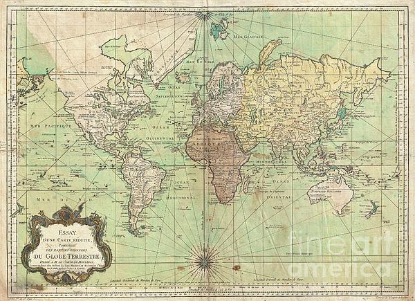
An attractive first edition first state example of J. N. Bellin’s 1778 nautical chart of the world. Presents the entire world on a Mercator... more
Ships Within
2 - 3 business days
An attractive first edition first state example of J. N. Bellin’s 1778 nautical chart of the world. Presents the entire world on a Mercator Projection based on a Paris (L’Isle de Fer) meridian. This is notably the first state of this important map, exhibiting a pre-Cook geography throughout, but most specifically in the Pacific and along the northwest coast of America. North America to the west of the Mississippi is vaguely rendered according to 16th century expeditions into the region by Coronado, La Salle, De Soto, and others. Bellin identifies the semi-mythical civilizations of Quivira and Teguayo, both associated with legends of the Seven Cities of Gold, in what is modern day Utah, California, and Nevada. Along the western coast the strait discovered by Martin Aguilar is noted. Further north still the River of the West (Fl. de l’Ouest) extends from the west coast to the Lake of the Woods (Lac de Bois) and thence via additional waterways to the Great Lakes and the Atlantic. Th...
My passion is Photography and Aviation or is that Aviation and Photography ! I hope you enjoy my photographs.
$73.00


There are no comments for 1778 Bellin Nautical Chart or Map of the World. Click here to post the first comment.