Sale on canvas prints! Use code ABCXYZ at checkout for a special discount!


The watermark at the lower right corner of the image will not appear on the final product.

by Paul Fearn
$28.00
Design Location
Color
Image Size
Product Details
Our Bella / Canvas t-shirts are made from a 50% cotton / 50% polyester blend and are available in five different sizes. All t-shirts are machine washable.
Design Details
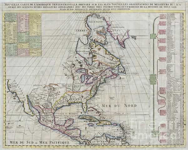
Offered here is a stunning map of North America published by Henry Chatelain for the 1720 edition of his seminal Atlas Historique. Offers some of the... more
Ships Within
1 - 2 business days
Offered here is a stunning map of North America published by Henry Chatelain for the 1720 edition of his seminal Atlas Historique. Offers some of the first well developed cartography of the Great Lakes region and considerable detail along the eastern seaboard. Indian tribes, Spanish missions, and explorer routes are all indicated with varying degrees of accuracy.Includes references to several mythical kingdoms and cities including Quivra (Quivira) just west of the Mississippi, and Cibola in New Mexico. Both Quivira and Cibola are among the “Seven Cities of Gold” sought after by early Spanish explorers in the North America. Legend tells that the cities were founded by bishops who fled the Moorish invasion of Merida, Spain, in 1150. Although numerous explorers sought the mythical cities, including Vásquez de Coronado, they were never found.This is also one of the first 18th century maps to question the myth that California was an island. Though many claim that this map depicts Calif...
My passion is Photography and Aviation or is that Aviation and Photography ! I hope you enjoy my photographs.
$28.00


There are no comments for 1720 Chatelain Map of North America. Click here to post the first comment.