Sale on canvas prints! Use code ABCXYZ at checkout for a special discount!

Boundary: Bleed area may not be visible.

The watermark at the lower right corner of the image will not appear on the final product.

by Paul Fearn
$27.00
Model
Case Style
Orientation
Image Size
Product Details
1696 Coronelli Map of the Great Lakes iPhone case by Paul Fearn. Protect your iPhone with an impact-resistant, slim-profile, hard-shell case. The image is printed directly onto the case and wrapped around the edges for a beautiful presentation. Simply snap the case onto your iPhone for instant protection and direct access to all of the phone's features!
Design Details
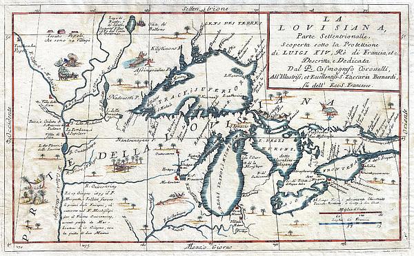
This exceedingly rare 1694 map by Vincenzo Coronelli is the most important depiction of the Great Lakes and the headwaters of the Mississippi River... more
Ships Within
3 - 4 business days
Protect your with an impact-resistant, slim-profile, hard-shell case. The image is printed directly onto the case and wrapped around the edges for a beautiful presentation. Simply snap the case onto your for instant protection and direct access to all of the phone's features!
This exceedingly rare 1694 map by Vincenzo Coronelli is the most important depiction of the Great Lakes and the headwaters of the Mississippi River to appear in the late 17th century. Covers all five Great Lakes and extends westward as far as the Mississippi River valley. This map is a careful study of the Great Lakes Region and reveals Coronelli’s fascination with this area. Coronelli derived his cartographic information from the reports of Jesuit Missionaries who were actively proselytizing in this region throughout the mid to late 18th century. These included the explorations of La Salle, Hennepin, Marquette and Jolliet, among others. Dotted with forts, Indian villages, and missionary stations. Shows the R. De Chekagou roughly where Chicago is today. Shows the Ottawa River route into Georgian Bay anda well developed mapping of Green Bay. This is also the most accurate early mapping of Lake Superior, in which both Keweenaw Peninsula (P. Kioanan) and Isle Royale (I. Miniong) are lo...
My passion is Photography and Aviation or is that Aviation and Photography ! I hope you enjoy my photographs.
$27.00


Ukrainian Artists
Paul, congratulations on your sale of this amazing photo!
Lazaro Hurtado
congrats