Sale on canvas prints! Use code ABCXYZ at checkout for a special discount!

Boundary: Bleed area may not be visible.

The watermark at the lower right corner of the image will not appear on the final product.

by Paul Fearn
$27.00
Model
Case Style
Orientation
Image Size
Product Details
1676 John Speed Map of Carolina iPhone case by Paul Fearn. Protect your iPhone with an impact-resistant, slim-profile, hard-shell case. The image is printed directly onto the case and wrapped around the edges for a beautiful presentation. Simply snap the case onto your iPhone for instant protection and direct access to all of the phone's features!
Design Details
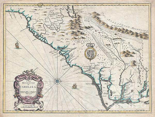
A beautiful example of John Speed's important 1676 map of the Carolina colony. Heavily based upon the explorations of John Lederer and Ogilby's Lords... more
Ships Within
3 - 4 business days
Protect your with an impact-resistant, slim-profile, hard-shell case. The image is printed directly onto the case and wrapped around the edges for a beautiful presentation. Simply snap the case onto your for instant protection and direct access to all of the phone's features!
A beautiful example of John Speed's important 1676 map of the Carolina colony. Heavily based upon the explorations of John Lederer and Ogilby's Lords Proprietor's Map of 1674. This seminal map represents one of the earliest attempts to map the Carolina interior. Oriented to the West, map covers from the Spanish colony of St. Augustine, Florida, north to Jamestown, Virginia. Extends inland as far as the Appellation (Apalathean) Mountains. By the middle of the 17th century the coast of Carolina had been fairly well mapped , St. Augustine, Port Royal, Charleston (Charles Town), Cape Fear, Cape Lookout, Cape Hatteras, Roanoke, Cape Henry and the James River are all shown with a fair approximation of accuracy. We see ample evidence of the Lords Proprietors including Albemarl County, Clarendon County, Berkley County, Craven County, etc. This map also incorporates numerous elements from earlier maps including Lake Sarrope, which was identified by the De Bry - Le Moyne map of 1565 and most lik...
My passion is Photography and Aviation or is that Aviation and Photography ! I hope you enjoy my photographs.
$27.00


There are no comments for 1676 John Speed Map of Carolina. Click here to post the first comment.