Sale on canvas prints! Use code ABCXYZ at checkout for a special discount!

Boundary: Bleed area may not be visible.


by Paul Fearn
$35.00
Size
Orientation
Image Size
Product Details
Our luxuriously soft beach towels are made from brushed microfiber with a 100% cotton back for extra absorption. The top of the towel has the image printed on it, and the back is white cotton. Our beach towels are available in two different sizes: beach towel (32" x 64") and beach sheet (37" x 74").
Don't let the fancy name confuse you... a beach sheet is just a large beach towel.
Design Details
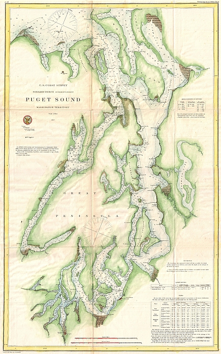
This is a very uncommon U.S. Coast Survey maritime map or nautical chart of the Puget Sound, Washington Territory, dating to 1867. Covers the Sound... more
Care Instructions
Machine wash cold and tumble dry with low heat.
Ships Within
1 - 2 business days
This is a very uncommon U.S. Coast Survey maritime map or nautical chart of the Puget Sound, Washington Territory, dating to 1867. Covers the Sound from Quimper Peninsula and Whidbey Island south as far as Olympia. The map identifies the various islands as well as safe channels and countless triangulation points throughout. Olympia, Nisqually, Steilacoom, and Seattle are named, though, aside from Olympia, most were undeveloped. Countless depth soundings appear throughout. Notes on soundings light houses, and tides appear in the lower right quadrant. Prepared under the supervision of Benjamin Pierce, Superintendent of the U.S. Coast Survey, for the 1867 Superintendent�s Report to Congress.
My passion is Photography and Aviation or is that Aviation and Photography ! I hope you enjoy my photographs.
$35.00


There are no comments for 1867 U.S. Coast Survey Chart or Map of Puget Sound, Washington. Click here to post the first comment.