Sale on canvas prints! Use code ABCXYZ at checkout for a special discount!
 Beach Towel featuring the photograph 1862 Johnson Military Map of the United States Civil War by Paul Fearn")
Boundary: Bleed area may not be visible.


by Paul Fearn
$35.00
Size
Orientation
Image Size
Product Details
Our luxuriously soft beach towels are made from brushed microfiber with a 100% cotton back for extra absorption. The top of the towel has the image printed on it, and the back is white cotton. Our beach towels are available in two different sizes: beach towel (32" x 64") and beach sheet (37" x 74").
Don't let the fancy name confuse you... a beach sheet is just a large beach towel.
Design Details
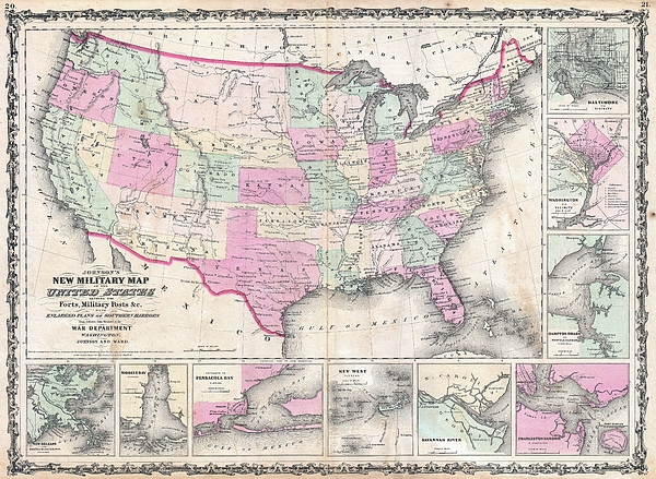
An exceptional example of A. J. Johnson�s highly desirable Military Map of the United States. Created at the height of the American Civil War, this... more
Care Instructions
Machine wash cold and tumble dry with low heat.
Ships Within
1 - 2 business days
An exceptional example of A. J. Johnson�s highly desirable Military Map of the United States. Created at the height of the American Civil War, this map was issued by Johnson in order to capitalize on the general interest in the War. This is the more desirable of the two extant variants of this map. This variant, showing a layout of the states rather than military zones, offers a wonderful insight into the political situation shortly following the outbreak of the American Civil War. Shows the various states and territories along with several hundred forts and other military installations. Includes the briefly extant Confederate Territory of Arizona occupying the southern portion of New Mexico Territory. This interesting territory was declared by the Texan Confederate Col. John Robert Baylor in 1861 and was in theory extant until the end of the Civil War, but in fact recaptured by Union forces scarcely a year later. Features the strapwork border common to Johnson�s atlas work from 1860 t...
My passion is Photography and Aviation or is that Aviation and Photography ! I hope you enjoy my photographs.
$35.00


There are no comments for 1862 Johnson Military Map of the United States Civil War . Click here to post the first comment.