Sale on canvas prints! Use code ABCXYZ at checkout for a special discount!

Boundary: Bleed area may not be visible.

The watermark at the lower right corner of the image will not appear on the final product.

by Paul Fearn
$35.00
Size
Orientation
Image Size
Product Details
Our luxuriously soft beach towels are made from brushed microfiber with a 100% cotton back for extra absorption. The top of the towel has the image printed on it, and the back is white cotton. Our beach towels are available in two different sizes: beach towel (32" x 64") and beach sheet (37" x 74").
Don't let the fancy name confuse you... a beach sheet is just a large beach towel.
Design Details
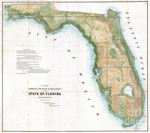
An extremely rare variant state of the 1849 Land Survey Map of Florida. Geographically this map corresponds to the 1848 Butler issue of this map, but... more
Care Instructions
Machine wash cold and tumble dry with low heat.
Ships Within
1 - 2 business days
An extremely rare variant state of the 1849 Land Survey Map of Florida. Geographically this map corresponds to the 1848 Butler issue of this map, but bears the Putnam imprint and 1849 date overprinting an earlier date of October and Butler’s imprint. Consequently this map was likely issued shortly after the transition from Butler to Putnam in the office of Surveyor General, yet before Putnam was able to create his own distinctive maps. This map represents the state of the Land Survey in Florida as of September 30, 1849. Shows the state divided into several hundred numbered plats, some of which are marked with an “S” to state that they had been fully surveyed, and some with a “T” suggesting that they had only been surveyed externally. Labels several important Seminole War Forts including Fort Bassinger, Fort Center, Fort Thompson, Fort Beynaud, Fort Adams, and others. Notes the Everglades, Big Cypress, Fort Lauderdale, Lake Okeechobee, and many of Florida’s lakes and river...
My passion is Photography and Aviation or is that Aviation and Photography ! I hope you enjoy my photographs.
$35.00


Gary F Richards
Congratulations on your sale of this wonderful artwork! F/L
Scott Dokey
Very cool! Congratulations!!!
Maj Seda
Beautiful artwork! Congrats!