Sale on canvas prints! Use code ABCXYZ at checkout for a special discount!

Boundary: Bleed area may not be visible.

The watermark at the lower right corner of the image will not appear on the final product.

by Paul Fearn
$35.00
Size
Orientation
Image Size
Product Details
Our luxuriously soft beach towels are made from brushed microfiber with a 100% cotton back for extra absorption. The top of the towel has the image printed on it, and the back is white cotton. Our beach towels are available in two different sizes: beach towel (32" x 64") and beach sheet (37" x 74").
Don't let the fancy name confuse you... a beach sheet is just a large beach towel.
Design Details
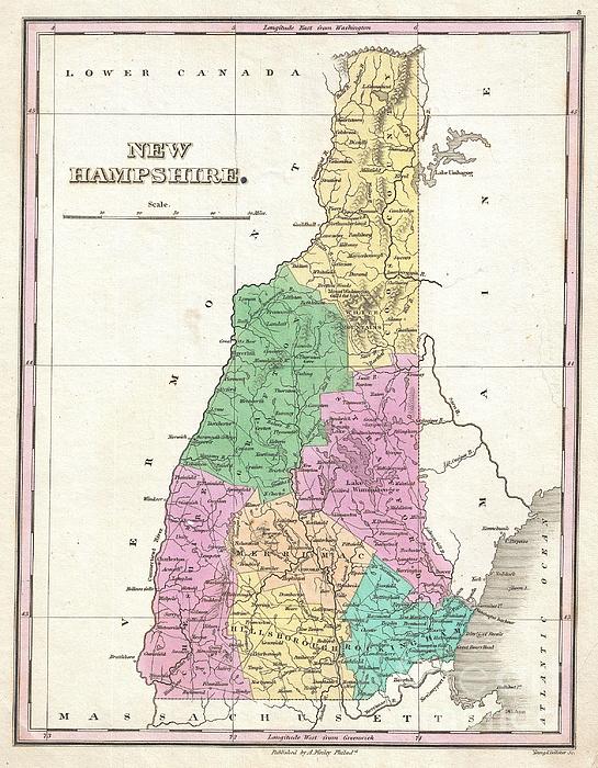
A beautiful example of Finley's important 1827 map of New Hampshire. Depicts the state with moderate detail in Finley's classic minimalist style.... more
Care Instructions
Machine wash cold and tumble dry with low heat.
Ships Within
1 - 2 business days
A beautiful example of Finley's important 1827 map of New Hampshire. Depicts the state with moderate detail in Finley's classic minimalist style. Shows river ways, roads, canals, and some topographical features. Offers color coding at the county level. Title and scale in lower right quadrant. It is very uncommon to find an early 19th century exclusively depicting New Hampshire, as most maps of the period bundled it with Vermont. Identifies Mount Monandnock, Mount Moosehillock, and Mount Washington. Engraved by Young and Delleker for the 1827 edition of Anthony Finley's General Atlas .
My passion is Photography and Aviation or is that Aviation and Photography ! I hope you enjoy my photographs.
$35.00


There are no comments for 1827 Finley Map of New Hampshire. Click here to post the first comment.