Sale on canvas prints! Use code ABCXYZ at checkout for a special discount!

Boundary: Bleed area may not be visible.

The watermark at the lower right corner of the image will not appear on the final product.

by Paul Fearn
$35.00
Size
Orientation
Image Size
Product Details
Our luxuriously soft beach towels are made from brushed microfiber with a 100% cotton back for extra absorption. The top of the towel has the image printed on it, and the back is white cotton. Our beach towels are available in two different sizes: beach towel (32" x 64") and beach sheet (37" x 74").
Don't let the fancy name confuse you... a beach sheet is just a large beach towel.
Design Details
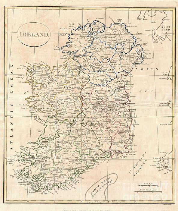
A fine 1799 map of Ireland by the English map publisher Clement Cruttwell. Map shows Ireland's four provinces, which remain the same to this day. In... more
Care Instructions
Machine wash cold and tumble dry with low heat.
Ships Within
1 - 2 business days
A fine 1799 map of Ireland by the English map publisher Clement Cruttwell. Map shows Ireland's four provinces, which remain the same to this day. In the north is Ulster, Connaught in the west, Leinster in the east, and Munster in the south. Leinster is comprised of Carlow, Dublin, Kildare, Kilkenny, Laois, Longford, Louth, Meath, Offaly, Westmeath, Wexford and Wicklow. Munster is made up of Clare, Cork, Kerry, Limerick, Tipperary and Waterford. In Connaught are Galway, Leitrim, Mayo, Roscommon and Sligo. Antrim, Armagh, Down, Fermanagh, Londonderry, Tyrone, Cavan, Donegal, and Monaghan make up Ulster. The map also shows some major roads, river ways, mountains and other topographical features. Off the coast, Cruttwell makes note of various shoals and, just south of the island, the Nymph Bank, discovered in 1735 by Captain Doyle. Features two units of measurement in the lower-right quadrant: Irish Miles and British Statute Miles. Outline color and fine copper plate engraving in the minim...
My passion is Photography and Aviation or is that Aviation and Photography ! I hope you enjoy my photographs.
$35.00


Gull G
“A creative man is motivated by the desire to achieve, not by the desire to beat others.” Congratulations on your recent sale of an amazing work!
Ausra Paulauskaite
Congratulations on your sale.
Cristina-Velina Ion
Congrats on your sale! :)
Lazaro Hurtado
congrats
Michael Porchik
Congrats on your sale!!