Sale on canvas prints! Use code ABCXYZ at checkout for a special discount!

Boundary: Bleed area may not be visible.

The watermark at the lower right corner of the image will not appear on the final product.

by Paul Fearn
$35.00
Size
Orientation
Image Size
Product Details
Our luxuriously soft beach towels are made from brushed microfiber with a 100% cotton back for extra absorption. The top of the towel has the image printed on it, and the back is white cotton. Our beach towels are available in two different sizes: beach towel (32" x 64") and beach sheet (37" x 74").
Don't let the fancy name confuse you... a beach sheet is just a large beach towel.
Design Details
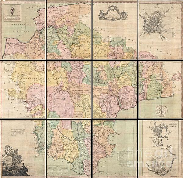
This is a very rare and highly important 1765 wall map of Devonshire by Benjamin Donn. Drawn in twelve panels, this map covers the entirety of... more
Care Instructions
Machine wash cold and tumble dry with low heat.
Ships Within
1 - 2 business days
This is a very rare and highly important 1765 wall map of Devonshire by Benjamin Donn. Drawn in twelve panels, this map covers the entirety of Devonshire or Devon from the English Channel to Barnstaple (Bideford) Bay and from Cornwall to Somerset at a scale of 1 inch to 1 mile. Donn also incorporates large insets of Exeter (showing the college), Plymouth, Plymouth Dock, Stoke Town, and the Isle of Lundy. An elaborate decorative title cartouche with various allegorical elements appears in the lower left quadrant. In 1759 the Society for the Encouragement of the Arts, Manufacturers, and Commerce (since 1847 known as the Royal Society for the Arts), following the suggestion of the Cornish antiquarian William Borlase, offered a £100 award for a large scale one inch to the mile map of any English county. Benjamin Donn, the first to step up to the Borlase’s challenge, began work on his map of Devon in 1760. Five years later Donn’s extraordinary project reached completion. The Society wa...
My passion is Photography and Aviation or is that Aviation and Photography ! I hope you enjoy my photographs.
$35.00


There are no comments for 1765 Benjamin Donn Wall Map of Devonshire and Exeter England. Click here to post the first comment.