Sale on canvas prints! Use code ABCXYZ at checkout for a special discount!

Boundary: Bleed area may not be visible.


by Paul Fearn
$47.00
This product is currently out of stock.
Size
Orientation
Image Size
Product Details
You'll never run out of power again! If the battery on your smartphone or tablet is running low... no problem. Just plug your device into the USB port on the top of this portable battery charger, and then continue to use your device while it gets recharged.
With a recharge capacity of 5200 mAh, this charger will give you 1.5 full recharges of your smartphone or recharge your tablet to 50% capacity.
When the battery charger runs out of power, just plug it into the wall using the supplied cable (included), and it will recharge itself for your next use.
Design Details
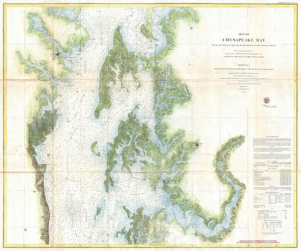
This is an attractive 1857 U.S. Coast Survey chart or nautical map or the central part of the Chesapeake Bay, Maryland. This is chart no. 2 of the... more
Dimensions
1.80" W x 3.875" H x 0.90" D
Ships Within
1 - 2 business days
This is an attractive 1857 U.S. Coast Survey chart or nautical map or the central part of the Chesapeake Bay, Maryland. This is chart no. 2 of the three charts created to detail the entire Chesapeake Bay. Covers from roughly 38.35 degrees north latitude to the mouth of the Potomac River. Includes the cities of Annapolis, Cambridge, and Easton, among others. Notes Kent Island, Oxford, Low's Island, Sharp's Island, Choptank River, Cambridge, Herring Bay & Holland Point. Detailed sailing instructions tidal information, and notes on light houses in the lower right quadrant. Based on a trigonometrical survey produced under the direction of F.R. Hassler and A.D. Bache.
My passion is Photography and Aviation or is that Aviation and Photography ! I hope you enjoy my photographs.
$47.00


Sunil Kapadia
Congratulations!
Sorin Apostolescu
Excellent work...
Anne-elizabeth Whiteway
I live near the Chesapeake Bay. This is an enlightening image. LF.