Sale on canvas prints! Use code ABCXYZ at checkout for a special discount!


by Paul Fearn
$32.00
Color
Image Size
Product Details
Our long-sleeve t-shirts are made from 50% cotton / 50% polyester blend and are available in five different sizes. All long-sleeve t-shirts are machine washable.
Design Details
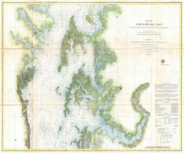
This is an attractive 1857 U.S. Coast Survey chart or nautical map or the central part of the Chesapeake Bay, Maryland. This is chart no. 2 of the... more
Ships Within
1 - 2 business days
This is an attractive 1857 U.S. Coast Survey chart or nautical map or the central part of the Chesapeake Bay, Maryland. This is chart no. 2 of the three charts created to detail the entire Chesapeake Bay. Covers from roughly 38.35 degrees north latitude to the mouth of the Potomac River. Includes the cities of Annapolis, Cambridge, and Easton, among others. Notes Kent Island, Oxford, Low's Island, Sharp's Island, Choptank River, Cambridge, Herring Bay & Holland Point. Detailed sailing instructions tidal information, and notes on light houses in the lower right quadrant. Based on a trigonometrical survey produced under the direction of F.R. Hassler and A.D. Bache.
My passion is Photography and Aviation or is that Aviation and Photography ! I hope you enjoy my photographs.
$32.00


Sunil Kapadia
Congratulations!
Sorin Apostolescu
Excellent work...
Anne-elizabeth Whiteway
I live near the Chesapeake Bay. This is an enlightening image. LF.