Sale on canvas prints! Use code ABCXYZ at checkout for a special discount!

Boundary: Bleed area may not be visible.

The watermark at the lower right corner of the image will not appear on the final product.

by Paul Fearn
$25.00
Size
Image Size
Product Details
Purchase a tote bag featuring the photograph "1795 Bowles Pocket Map of London" by Paul Fearn. Our tote bags are made from soft, durable, poly-poplin fabric and include a 1" black strap for easy carrying on your shoulder. All seams are double-stitched for added durability. Each tote bag is machine-washable in cold water and is printed on both sides using the same image.
Design Details
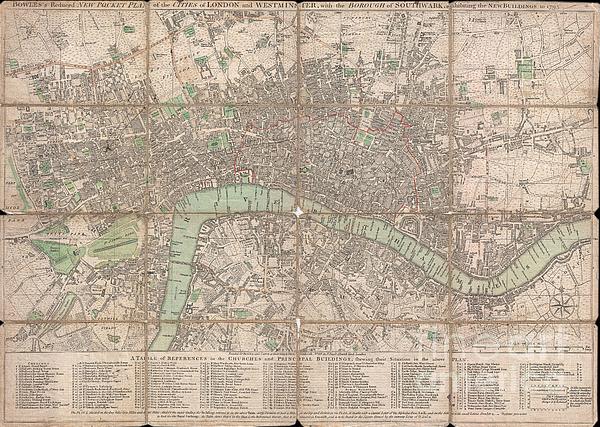
This is a rare 1795 folding pocket map or street plan of London, England by Carrington Bowles. Covers London on both sides of the Thames River from... more
Ships Within
2 - 3 business days
This is a rare 1795 folding pocket map or street plan of London, England by Carrington Bowles. Covers London on both sides of the Thames River from Hyde Park in the west to White Horse Street in the East and from Lambeth in the south to Islington in the North. Offers superb detail throughout often noting individual buildings, gardens, and estates. Table along the bottom notes principle buildings and churches. Bowles first issued this plan in 1777 and updated it regularly to the end of the 18th century. This edition of the map was issued shortly after Bowles's death by his firm, Bowles and Carver, from their offices at No. 69 St. Paul's Church Yard, London.
My passion is Photography and Aviation or is that Aviation and Photography ! I hope you enjoy my photographs.
$25.00


Sergey Taran
Nice gallery!
Nina Prommer
Congrats!
Bill Cannon
Congratulations on your sale!!!!
Lazaro Hurtado
Congrats!