Sale on canvas prints! Use code ABCXYZ at checkout for a special discount!

Boundary: Bleed area may not be visible.

The watermark at the lower right corner of the image will not appear on the final product.

by Paul Fearn
$70.00
This product is currently out of stock.
Image Size
Product Details
Here it is... the towel that's taking the internet by storm. Our round beach towels are 60" in diameter and made from ultra-soft plush microfiber with a 100% cotton back. Perfect for a day at the beach, a picnic, an outdoor music festival, or just general home decor. This versatile summer essential is a must-have this season!
Design Details
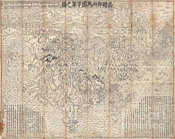
A seminal map of extreme significance. This is the first Japanese printed map to depict the world, including Europe and America, from a Buddhist... more
Dimensions
60" Diameter Not Including Tassles
Care Instructions
Machine wash cold and tumble dry with low heat.
Ships Within
2 - 3 business days
A seminal map of extreme significance. This is the first Japanese printed map to depict the world, including Europe and America, from a Buddhist cosmographical perspective. Printed by woodblock in 1710 (Hoei 7), this map was composed by the Buddhist monk Rokashi Hotan. Inspired by the 1653 publication of Si-yu-ki, a pilgrimage narrative of the Chinese monk Hsuang-Tsang's (602-604) travels to India in search of sacred Sanskrit writings, Rokashi Hotan's map attempts to update Buddhist mythological cartography, as exemplified in the 1634 manuscript map Gotenjikuzu (Map of the Five Regions of India), to correspond with the Si-yu-ki, as well as with contemporary and ancient religious texts, Chinese annals, travel narratives, and even some European maps. Rokashi Hotan lists these texts, 102 in all, at the top of the map. The consequent product of Rokashi Hotan's work is this magnificent amalgam of disparate ideas and traditions. In essence this is a traditional Buddhist world view in the Got...
My passion is Photography and Aviation or is that Aviation and Photography ! I hope you enjoy my photographs.
$70.00


Jeff Brassard
superb!