Sale on canvas prints! Use code ABCXYZ at checkout for a special discount!

Boundary: Bleed area may not be visible.


by Paul Fearn
$25.00
Size
Image Size
Product Details
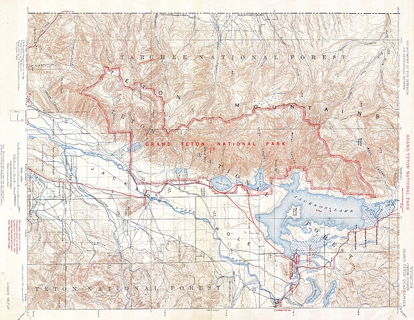
Purchase a tote bag featuring the photograph "1929 USGS Map of Grand Teton National Park Wyoming " by Paul Fearn. Our tote bags are made from soft, durable, poly-poplin fabric and include a 1" black strap for easy carrying on your shoulder. All seams are double-stitched for added durability. Each tote bag is machine-washable in cold water and is printed on both sides using the same image.
Design Details
This beautiful and fascinating topographical chart depicts Grand Teton National Park in Wyoming. This map was made shortly after Grand Teton National... more
Ships Within
2 - 3 business days
This beautiful and fascinating topographical chart depicts Grand Teton National Park in Wyoming. This map was made shortly after Grand Teton National Park was established in 1929. The park�s main attraction are its stunning U shaped valleys at the foot fo the towering Teton Range � part of the Rockies. The park is named for Grand Teton, the largest mountain in the range at a 4197 meters. Today Grand Teton, just south of Yellowstone, is one of America�s most beautiful National Parks.
My passion is Photography and Aviation or is that Aviation and Photography ! I hope you enjoy my photographs.
$25.00


Gene Parks
Congratulations on your recent sale!!