Sale on canvas prints! Use code ABCXYZ at checkout for a special discount!

Boundary: Bleed area may not be visible.

The watermark at the lower right corner of the image will not appear on the final product.
Inside Message (Optional)
Inside View

by Paul Fearn
$6.45
Quantity
The more you buy... the more you save.
Orientation
Image Size
Product Details
Our greeting cards are 5" x 7" in size and are produced on digital offset printers using 100 lb. paper stock. Each card is coated with a UV protectant on the outside surface which produces a semi-gloss finish. The inside of each card has a matte white finish and can be customized with your own message up to 500 characters in length. Each card comes with a white envelope for mailing or gift giving.
Design Details
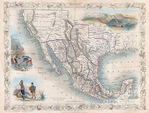
An exceptional example of John Tallis and John Rapkin's highly desirable 1851 Map of Mexico, Texas, and Upper California. Herein Texas is depicted at... more
Ships Within
2 - 3 business days
An exceptional example of John Tallis and John Rapkin's highly desirable 1851 Map of Mexico, Texas, and Upper California. Herein Texas is depicted at its fullest extent including both Santa Fe and a northern extension encompassing the Green Mountains. Drawn at the height of the California Gold Rush, this map responds to the international interest in the region by highlighting the gold fields in the Sacramento and San Joaquin valley. The “Great Caravan Route” used by covered wagons during the westward expansion is also noted. Tallis and Rapkin erroneously combine Great Salt Lake and Utah Lake - a curious and uncommon mistake that is most likely merely and engravers blunder. Upper California is surrounded by a green border, likely meant to communicate its transfer to the United States following the Treaty of Guadeloupe-Hidalgo, though such is not specifically noted anywhere on the map. Similarly, Texas, though clearly separated from Mexico is not clearly part of the United States. Th...
My passion is Photography and Aviation or is that Aviation and Photography ! I hope you enjoy my photographs.
$6.45


There are no comments for 1851 Tallis Map of Mexico Texas and California . Click here to post the first comment.