Sale on canvas prints! Use code ABCXYZ at checkout for a special discount!

Boundary: Bleed area may not be visible.

The watermark at the lower right corner of the image will not appear on the final product.

by Paul Fearn
$25.00
Size
Image Size
Product Details
Purchase a tote bag featuring the photograph "1787 Boulton Sayer Wall Map of Africa" by Paul Fearn. Our tote bags are made from soft, durable, poly-poplin fabric and include a 1" black strap for easy carrying on your shoulder. All seams are double-stitched for added durability. Each tote bag is machine-washable in cold water and is printed on both sides using the same image.
Design Details
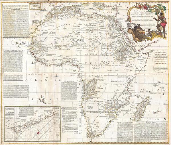
This is most likely the most important map of Africa produced in the 18th century. Printed at the height of the slave trade in 1787 by the Robert... more
Ships Within
2 - 3 business days
This is most likely the most important map of Africa produced in the 18th century. Printed at the height of the slave trade in 1787 by the Robert Sayer firm of London, England. Largely based upon the earlier D’Anville map, this map has been enlarged and expanded by Samuel Boulton. Depicts the continent in full with insets of the Gold Coast (or Ivory Coast, or Guinea). This map is unique in that it is a serious attempt to compile all of the accurate scientific knowledge of the African continent available at the time. In contrast to may other cartographers of the period there almost no attempt to fill the “unknown” regions of the interior with fictitious beasts, kingdoms, and geological features. Boulton himself advertises “The inland parts of Africa being but very little known and the names of the regions and countries which fill that vast tract of land being for the greatest part placed by conjecture it may be judged how absurd are the divisions traced in some maps and why they...
My passion is Photography and Aviation or is that Aviation and Photography ! I hope you enjoy my photographs.
$25.00


Roger Reeves and Terrie Heslop
Congratulations on your Fine Sale!!