Sale on canvas prints! Use code ABCXYZ at checkout for a special discount!

Boundary: Bleed area may not be visible.

The watermark at the lower right corner of the image will not appear on the final product.

by Paul Fearn
$43.00
Size
Rope Color
Image Size
Product Details
Our weekender tote bags are chic and perfect for a day out on the town, a staycation, or a weekend getaway. The tote is crafted with soft, spun poly-poplin fabric and features double-stitched seams for added durability. The 1" thick cotton handles are perfect for carrying the bag by hand or over your shoulder. This is a must-have for the summer.
Design Details
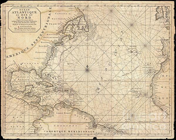
This is a rare and remarkable 1693 nautical chart of the Atlantic Ocean by Pierre Mortier. Covers the North Atlantic from rough 5 degree south... more
Care Instructions
Spot clean or dry clean only.
Ships Within
2 - 3 business days
This is a rare and remarkable 1693 nautical chart of the Atlantic Ocean by Pierre Mortier. Covers the North Atlantic from rough 5 degree south latitude to roughly 56 degrees north latitude. Includes much of North America, all of the West Indies and Caribbean, Central America, the northern parts of South America, Western Africa, Ireland, and parts of Western Spain. As a whole Mortier's map presents a moderately accurate picture of the Americas. The coast lines, particularly in North America are a unnaturally craggy. Florida takes on an inverted cone aspect. The barrier islands and capes off the coast of Virginia and Carolina are noted, but inaccurately represented. The Chesapeake Bay is slightly diminished in size. The entrance to the Mississippi River is either not apparent or confused with the conjectural Rio de Spirito Sancto. This river, most likely associated with early entradas into Mobile Bay, was confused with the Mississippi on numerous older maps. Politically, Mortier recogni...
My passion is Photography and Aviation or is that Aviation and Photography ! I hope you enjoy my photographs.
$43.00


Bill Cannon
Congrats on your sale!!!
Jon Burch Photography
Congratulations on your new $ale
Lazaro Hurtado
congrats!
RC DeWinter
Nice work, nice sale.
Bill Cannon
Congrats on your sale!!!
Odon Czintos
Congratulations on your sale.
Irina Sztukowski
Congratulations on you sale !!!