Sale on canvas prints! Use code ABCXYZ at checkout for a special discount!

Boundary: Bleed area may not be visible.

The watermark at the lower right corner of the image will not appear on the final product.

by Paul Fearn
$17.00
Size
Orientation
Image Size
Product Details
Decorate your bathroom and dry yourself off with our luxuriously soft bath towels and hand towels. Our towels are made from brushed microfiber with a 100% cotton back for extra absorption. The top of the towel has the image printed on it, and the back is white cotton. Available in three different sizes: hand towel, bath towel, and bath sheet.
Design Details
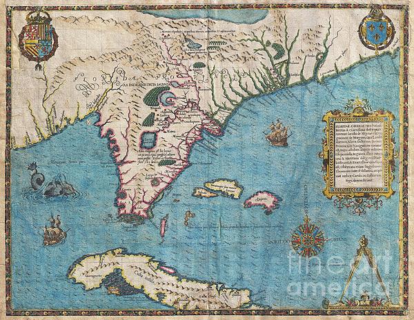
The most remarkable and important map, which has been preserved from the sixteenth century maps, of that part of the East Coast which lies between... more
Care Instructions
Machine wash cold and tumble dry with low heat.
Ships Within
1 - 2 business days
the most remarkable and important map, which has been preserved from the sixteenth century maps, of that part of the East Coast which lies between Cape Hatteras and Cape Florida … the first French map to show Florida … considered the most important map of Florida. - Johns Matthews Baxter A map of extraordinary rarity and seminal importance, this is one of the earliest and most influential maps of the American southeast ever published. Drawn by the French artist Jacques Le Moyne de Morgues c. 1565 and published by Theodore de Bry in 1591, this magnificent map details the Florida peninsula and Carolina coast from Cuba to the Bahamas, to “Prom Terra flag” or, as it is known today, Cape Lookout near Beaufort, North Carolina. The fascinating story of this map begins with the ambitions of the influential Huguenot Admiral Gaspard de Coligny. De Coligny, desirous of a French foothold on the American mainland sent the talented navigator Jean Ribaut to establish a colony. In 1562 Ribaut...
My passion is Photography and Aviation or is that Aviation and Photography ! I hope you enjoy my photographs.
$17.00


Robin Maria Pedrero
Fantastic!!! Congrats!